Teacher Edition | View the Map
Week of November 17, 2024
Right click and SAVE AS
to download the Google Earth file for this episode
Use free Google Earth software
to OPEN it, using File> Open.
Find more tech info here.
I have been researching why this map has so many lines running up and down and across, and Meri finally explained it to me. Here is the lowdown on these lines. The lines that run up and down the map (north and south) are called longitude lines. These lines are used to measure degrees east or west from the prime meridian. The prime meridian is located at 0 degrees longitude. This imaginary line runs up and down through France, Spain, Antarctica, western Africa, and the United Kingdom. The prime meridian divides the world into the eastern hemisphere and western hemisphere. (Hemisphere means half of a sphere). The lines that run across (east and west) a map are called latitude lines. Lines of latitude measure degrees via north or south. The equator is at 0 degrees latitude. This imaginary line marks halfway between the North Pole and the South Pole. The equator runs through parts of Asia, South America, and Africa. This imaginary line also divides the world into the southern hemisphere and northern hemisphere. Longitude and latitude are both used to measure distance in "degrees".
I am still trying to think of a way to tell the two kinds apart. Wow, Meri just taught me an easy way to remember the directions of the lines. Think of latitude as a "ladder" (kind of sounds similar). The steps of a ladder go up and down just like the lines of latitude go around the map. I put some pictures in my blog to better explain this confusing geography stuff. Both lines (latitude and longitude) start at 0. These lines are drawn only on maps and globes. So, don't expect to see an "equator line" on the streets and beaches of Brazil! I wonder how longitude and latitude help us -- or why they are even used? Meri explained that the purpose of longitude and latitude is to help identify your specific location on the earth's surface. Uncle GT also text me this neat picture of a globe/map (it really helped me to understand what all of those lines represent). See my pictures below.
- Geo
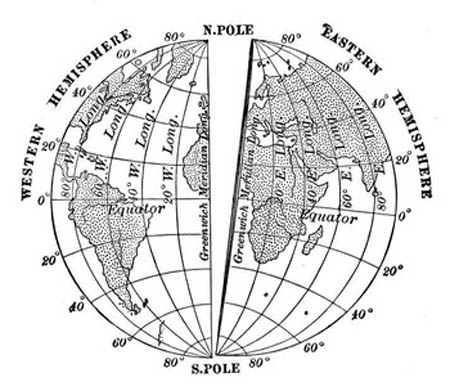
This picture shows the prime meridian, equator, eastern and western hemispheres, lines of latitude, and lines of longitude.
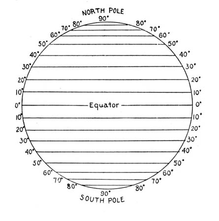
This picture shows the lines of latitude. Do you see the equator? The lines of latitude run across a map, but they measure degrees north and south from the equator. The lines of latitude are like the steps of a ladder on the globe.
South America Map
Check out this map of South America. Can you believe the size of Brazil? Look at how many rivers there are. Can you find the Amazon?
Uncle GT called today and told us to "hang tight" in Brazil. He hadn't heard any updates about Dewey, the truth-sniffing dog. We are to keep our cell phones with us at all times and take some time to explore this huge country. Geo and I are taking a helicopter to the Amazon Rainforest in about an hour. I can't wait to go explore the rainforest. Our trip includes a canopy tour. Do you know what that is? A canopy tour takes you through the rainforest via steel cables and platforms. We are going to be kind of like Tarzan gliding through the rainforest. The steel cables and platforms are installed on trees between 10-20 meters from the ground (that would equal 30-60 feet). Holy Idaho! I can't wait to get gliding. Geo is excited too. We will be gone all day - so we will write more tomorrow. We just received a text message from our little sister, Pandora.
Text from Pandora: WAYN? RUOK?
Text to Pandora: ABT2 go on canopy tour in Amazon. In btfl C-T in Brazil
- Meri
Christmas in Brazil
Take a look at some of the neat Christmas traditions in Brazil.
The Amazon canopy tour was the most thrilling experience of my entire life. Meri was a bit nervous to get started, but once she got going - she loved it too! I posted some pictures of the Amazon rainforest below. I also posted a picture of another tourist on a canopy tour (this is the person who went after Meri).
Tonight we received an odd text message from an unknown caller:
Dewey is safe. Stop following us. We need Dewey for our project. We are northwest of Brasilia and in a country located in both the northern and southern hemispheres. The capital city begins with a B. Dewey is here. Where could we be?
In the words of Meri, "Holy Idaho". Take a look at the map and see if you can figure out where we should go next. The country is in the northern hemisphere and southern hemisphere, so that must mean that the equator runs through the country. The capital city begins with a B. And they are northwest of Brasilia. Should we travel to the capital of Chile, Colombia, or Ecuador? Take a look at the map and help us out!
- Geo
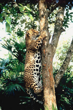
There are also Jaguars The main population of Jaguars live in the Orinoco Basin of Venezuela. Everywhere else that Jaguars are found in the world, they are endangered.
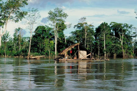
This is a picture of the Amazon River.
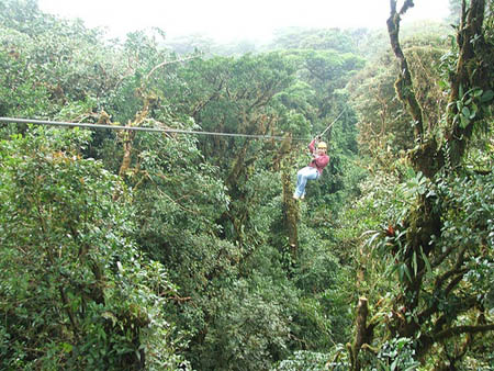
Here is a photo we found on the Internet of a canopy tour.
Map of South America
The country is in the northern and southern hemispheres, meaning that the equator runs through the country. The capital city begins with a B. And they are northwest of Brasilia. Can you figure out where we should go next?
equator - an imaginary line on the earth's surface that is positioned halfway between the north pole and the south pole. The equator divides the earth into the northern hemisphere and the southern hemisphere.
hemisphere - half of a sphere.
latitude - the lines that run across (east and west) a map. Lines of latitude measure degrees via north or south. The equator is at 0 degrees latitude.
longitude - lines that run up and down the map (north and south). These lines are used to measure degrees east or west from the prime meridian. The prime meridian is located at 0 degrees longitude.
northern hemisphere - the half of the planet Earth that is north of the equator. The northern hemisphere contains 90% of the human population and most of the land on the Earth.
prime meridian - the imaginary line that runs up and down a map or globe. It is found at 0 degrees longitude. This imaginary line runs vertically through the United Kingdom, France, Spain, western Africa, and Antarctica. The prime meridian divides the world into the eastern hemisphere and western hemisphere.
southern hemisphere - the half of the planet Earth that is south of the equator. The southern hemisphere contains all of Antarctica and Australia, most of South America, and part of Asia and Africa.
Back to topAdditional Web Resources:
World Atlas
This website provides maps and information about the landforms of South America.
Grade 3-5: Knows the basic elements of maps and globes (title, legend, cardinal, scale, grid, meridians, time zones, etc.).
Grade 3-5: Uses map grids (e.g., latitude and longitude or alphanumeric system) to plot absolute location.
Grade 6-8: Understands concepts such as axis, seasons, rotation, and revolution.
Grade 3-5: Knows major physical and human features of places as they are represented on maps and globes. Knows how to read different maps: road, relief, globe, etc..
Grade 6-8: Knows the location of physical and human features on maps and globes (e.g., culture hearths such as Mesopotamia, Huang Ho, the Yucatan Peninsula, the Nile Valley; major ocean currents; wind patterns; land forms; climate regions).
Grade 6-8: Knows the relative location of, size of, and distances between places.
Grade 6-8: Knows the physical characteristics of places (soil, vegetation, wildlife, etc..).
Grade 3-5: Knows the characteristics of a variety of regions (climate, housing, religion, language, etc..).
Grade 6-8: Understands criteria that give a region identity (such as Amsterdam as a transportation center or the Sunbelt's warm climate and popularity with retired people).
Grade 3-5: Knows how Earth's position relative to the Sun affects events and conditions on Earth.
Grade 3-5: Knows plants and animals associated with various vegetation and climatic region on Earth (i.e. kinds of plants and animals found in the rainforests of Africa).
Grade 3-5: Knows how and why people divide Earth's surface into political and/or economic units (e.g., states in the United States and Mexico; provinces in Canada; countries in North and South America; countries linked in cooperative relationships, such as the European Union).
Grade 6-8: Understands the symbolic importance of capital cities (such as Canberra, a planned city, as the capital of Australia).