Teacher Edition | View the Map
Week of October 13, 2024
Right click and SAVE AS
to download the Google Earth file for this episode
Use free Google Earth software
to OPEN it, using File> Open.
Find more tech info here.
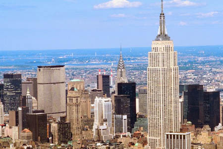
Meri and I had to be at the Phoenix airport by 5:00 am. Our flight took off on time at 7:00 am. I was thankful to be headed somewhere cooler after all of the high temperatures we have been having in Phoenix the past few weeks. We arrived on a nice cool day in New York City: 50 degrees. Meri actually needed to put on her sweater! We arrived at the Empire State Building at 3:00 pm (New York Time), which is only 12:00pm in Phoenix since Arizona doesn't participate in Daylight Saving. I'll paste in the snapshot that I took of the Empire State Building at the end of this entry. It's the tallest building in the picture. Isn't this city beautiful! After we arrived at the Empire State Building, a government agent came up to us and showed us his badge. He said he remembered meeting us at the company picnic at Uncle GT's lake house last summer. The agent handed us the purple folder; in it, we found another letter from Uncle GT.
Dear Geo and Meri,
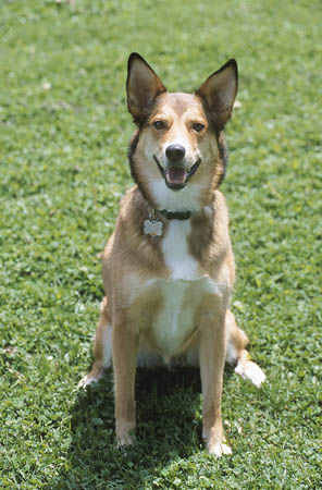
I am glad that you arrived safely at the Empire State Building. Do you both remember Dewey, the department's truth-sniffing dog? I remember last summer at my lake house; Dewey was very comfortable with you two. Dewey usually doesn't warm up to humans the way that he did to both of you - so we thought you were perfect for this job. Dewey was on a flight from Washington, D.C., to New York City. When his flight arrived at JFK airport, Dewey managed to run out of his unlocked kennel. He probably caught a whiff of something very true. Dewey was on his way to a secret mission helping a leading team of scholars to find out the truth about global warming, and they really need him back. He is the only known truth-sniffing dog in the world today, though he looks like an ordinary mutt. Just in case you forget what Dewey looks like - I have attached a recent picture.
We need your help finding Dewey ASAP! The government is afraid to publicize the fact that he is missing for fear that he will be found by the "wrong kind of people" and used for bad things. The airline is certain that Dewey did not leave the terminal (security would have noticed his departure). We are pretty sure that he ended up on another flight. We need you to go to JFK airport and do some investigative research. Call me on my cell (you know the number) with any questions or with any information that you can determine. Please use the enclosed credit card for all necessary purchases. You are approved to use the credit card for hotels, food, airfare, tourist attractions, and any other needs that may arise. Good luck, and enjoy this adventure!
Love,
Uncle GT
Meri and I are so excited to get started investigating at JFK. I attached a link for a map that was included with the note from Uncle GT. Take a look at the map.
Meri and I can only investigate JFK daily from 8 am - 5 pm. We have to call and speak with JFK during the daytime shift; since that is the timeframe that Dewey was "lost." Those employees would know the most information about the case. We already have a call into the airport to get video surveillance of the terminal where Dewey's plane landed. They agreed to share it with us virtually, but only for a total of 30 minutes of time, which should be enough since we know the plane's landing time. That is all that we know for now. We plan to visit the monuments and other attractions around our investigation schedule. I am sure Meri and I are going to be busy investigating the case, but we will be sure to update our blog as soon as we find any clues about Dewey, the truth-sniffing dog.
- Geo

NYC and the Empire State Building

Dewey the Truth-Sniffing Dog
Interactive Map of JFK and Surrounding Areas
Use this map to explore JFK and the surrounding areas. Click the map to see the details in each terminal.
Pandora to us: WAYN? RUOK? r u on r continent - No. Amer? Answer ASAP, Pls.
Us to Pandora: We r in No. Amer. on E Coast. Can't tell you where we r, but c-t is btfl. We r in a c-t on an estuary island...big port.
That text message will keep Pandora busy. She will probably have to look up the meaning of an estuary. I wonder why anyone would build a city on an island where rivers meet the ocean (a.k.a. - estuary)? Meri and I did some research and discovered that New York City was built as a port because boats, roads, and people could go to so many places from here. Now there are so many big buildings, they cover the entire island - a lot more buildings than in Phoenix.
- Geo
One day in New York City: 360° Virtual Tour
Take a tour of New York City!
New York City 8K - VR 360 Drive
Click and drag to view the city in 360 degrees!
Virtual Tour: New York, Manhattan HD
Check out this tour (from the sky). The buildings are all so tall.
Look at the map (don't forget to zoom in) and see which terminal is to the left of terminal 2. We also questioned the airline employees who were working at terminal 2, and they told us that if he went to terminal 1, there was only one more flight that night (to Anchorage, Alaska). Terminal 3 had two flights in that timeframe (one was to Seattle, Washington, and the other to Vancouver, Canada). So please take a look at the map and tell us which terminal we should call next to see if we can find Dewey. Remember, we saw him leaving terminal 2 and turning left. We just don't know where he went next. The airline feels awful for losing Dewey. I wonder how he boarded a plane with no one noticing. Something fishy is going on here. I hope we find him soon!
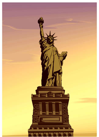
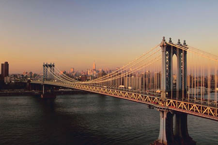
Boy, did that dog have a long flight. He is either in Seattle (Washington), Vancouver (Canada), or Anchorage (Alaska). At least we know he is still in North America because all three cities are on the continent of North America. So now Geo and I must figure out where we will travel next. The airline has offered us an immediate flight to any of the three cities; we hope to see Dewey by tomorrow! I have attached some other pictures that I took while in New York City.
So now we need some help from you. Please vote so we know what to do -
Which terminal do you think Dewey, the truth-sniffing dog, went to when he turned left after leaving terminal 2??
- Meri

The Statue of Liberty

The beautiful Brooklyn Bridge - a suspension bridge
Map of JFK Airport
Use this map to determine which terminal is to the left of terminal 2. We need your map skills!
cardinal direction - a term used to describe all four primary directions (north, south, east and west).
daylight saving - a way states and countries change their clocks in spring and fall to make better use of daylight. It moves an extra hour of daylight to afternoon during March to October. This helps people who work outside. Daylight saving time also conserves energy, moving activities into the daylight so we do not need to use lights. Not all places participate in daylight saving time.
estuary - the meeting place for fresh water (rivers) and salt water (oceans). Many cities located at estuaries have become important centers of commerce due to the convenience of the port.
scale - shows the relationship between the distance on a map and the corresponding distance on the earth. For example, 1 inch may equal 500 miles. This allows users to calculate the approximate distance between two locations on a map.
suspension bridge - a bridge that is created by using a deck supported by large cables hung from the towers. The Brooklyn Bridge is one of the oldest suspension bridges in the United States (built from 1870 - 1883). It is 5,989 feet long.
Back to topAdditional Web Resources:
Statue of Liberty
Use this website to learn more about the Big Apple.
Grade 3-5: Knows the basic elements of maps and globes (title, legend, cardinal, scale, grid, meridians, time zones, etc.).
Grade 3-5: Knows major physical and human features of places as they are represented on maps and globes. Knows how to read different maps: road, relief, globe, etc..
Grade 3-5: Knows the location of major cities in North America.
Grade 6-8: Knows the relative location of, size of, and distances between places.
Grade 3-5: Knows different methods to measure data (miles, kilometers, time, etc..).
Grade 6-8: Understands distributions of physical and human occurrences with respect to spatial patterns, arrangements, and associations (e.g. why some areas are more densely settled than others).
Grade 3-5: Knows how communities benefit from the physical environment (e.g., people make their living by farming on fertile land, fishing in local water, working in mines; the community is a port located on a natural harbor, a tourist center located in a scenic or historic area, an industrial center with good access to natural resources).
Grade 3-5: Knows the basic elements of maps and globes (title, legend, cardinal, scale, grid, meridians, time zones, etc.).